Panama Canal – “Bridge of the Americas”
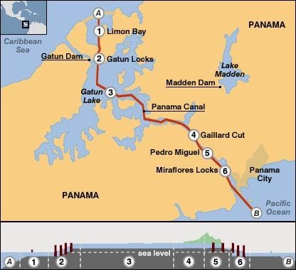
The Panama Canal was built and finished in 1914, and officially opened in 1920. The Panama Canal, which spans the isthmus and connects the Atlantic and Pacific Oceans, was the most massive construction project of its day. It is now owning and manages by Panama. The canal is 40 miles (77 kilometers) long from one end to the other, and traveling across it may takes around 10 hours. Throughout the 1800s, American and British governments and businessmen desired to transport goods between the Atlantic and Pacific coastlines fast and cheaply.
The Panama Canal’s commerce is a measure of global commerce, growing in times of global prosperity and reducing in times of recession. Traffic increased from a low of 807 transits in 1916 to a peak of 15,523 transits of all sorts in 1970. More than 132.5 million long tons (134.6 million metric tons) of goods were transported via the canal in the same year of 1970. Despite the fact that the number of yearly transports has dropped since then, the canal still transports more freight than ever before due to the increasing average size of vessels and barges. In 2013, the canal carried over 210 million long tons (213 million metric tons) of goods.
Apart from the fact that the Panama Canal significantly improved the efficiency of commodities transportation across lands. It was also intended to ensure Panama’s independence. Although US management of the canal subsequently became a source of friction in US-Panamanian relationships, it was viewed as a good example of foreign policy accomplishment at the time and still sees as the world greatest engineering project in the past century.
Source: https://www.britannica.com/topic/Panama-Canal/Canal-traffic
https://www.history.com/news/7-fascinating-facts-about-the-panama-canal
South-to-north water diversion project in China
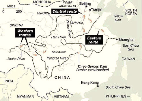
In China, the South-to-North Water Diversion Project invovles extracting water from southern rivers and delivering it to the arid north. This project, which is now being expanded and is scheduled to be completed in 2050, would eventually transfer 44.8 billion cubic meters of water yearly to the population centers of northern China.
The plan was originally proposed by China’s Chairman Mao Zedong in 1952, with the goal of alleviating rising water shortages in Beijing and Tianjin, as well as the northern provinces of Hebei, Henan, and Shandong. On 23rd August 2002, after extensive research, planning and discussion, the project was approved by the State Council and work began the project in December.
Several issues occur during construction, including heavily contaminated water entering the lake. At least 330,000 people in central China had to be relocated as part of the project. Environmentalists have warned that the water diversion will harm the ecosystem and even increase the water evaporation rate. The exact amount of evaporation loss is remained unknown but it may be improved in the future as more water is transferred and the flow rate increases.
However, there are still some advantages that the project brought to people in North China. This project largely reduced water insecurity in China, supported economic growth. Fodd secuirty improved as well as more water available for agriculture field. It had also reduced a large amout of groundwater extraction.
Source: https://www.water-technology.net/projects/south_north/
https://www.internetgeography.net/topics/the-south-north-water-transfer-project-in-china/
Suez Canal
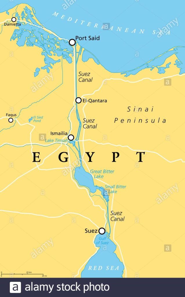
This canal connect the Mediterranean and the Red seas. The canal separates the African continent from Asia, and it provides the shortest maritime route between Europe and the lands lying around the Indian and western Pacific oceans. Since its completion in 1869, it has become one of the world’s most heavily used shipping lanes. It is important canal because prior to its construction, ships headed toward Asia had to embark on an arduous journey around the Cape of Good Hope at the southern tip of Africa. Now after the canal built, it provided shorter route and heavily used. The Suez canal was built to serve, and profit from, international trade, its international status remained undefined for many years. The canal should be open to ships of all nations in both peacetime and wartime.
For many years, the canal’s limited width and poor depth made it impossible to handle two-way traffic from modern tanker ships. The Suez Canal Authority of Egypt proposed an proposal to enlarge the canal and build a new 22-mile lane branching off the main channel in 2014. However, modifications were insufficient to prevent a 1,300-foot cargo ship from being stuck in the canal while traveling from China in March 2021. For over a week, the ship jammed more than 100 ships at each end of the key maritime channel, creating severe delays to global trade.
Source: https://www.britannica.com/topic/Suez-Canal
https://www.history.com/news/9-fascinating-facts-about-the-suez-canal
Leeds and Liverpool canal
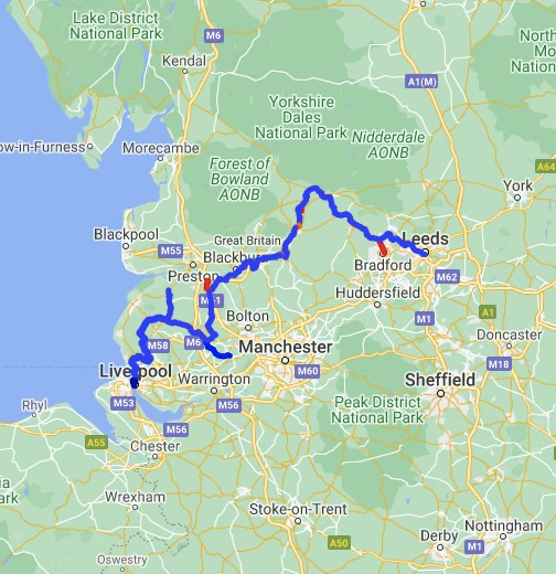
This 127-mile canal was under construction for nearly 40 years and eventually open on 1816. It is the longest canal in Britain built as a single waterway. It is the UK’s longest canal constructed as a single waterway. The canal leaves Liverpool and travels through East Lancashire before passing through Pennine on the outskirts of the Yorkshire Dales before arriving in Leeds. The Leeds & Liverpool Canal is a wide canal that allows Yorkshire keels to pass across the Pennines. Yorkshire merchants were desperate to get lime and limestone from the Craven District to fertilize agricultural land and make a cement to expand the size and height of weaving structures. The canal also allowed access to export channels to African and American markets via Liverpool, as well as a coal supply from Wigan to Liverpool. There are five branches: Rufford Branch are7.25 miles, Leigh Branch which is 7.5 miles, Springs Branch, 0.5 miles and Stanley Docks Branch with length of 0.3 miles, lastly the Walton Summit Branch which now closed and filled in. With the opening of the Ribble Link in 2002, investment in the canal has continued into the 21th century. The Leeds & Liverpool Canal and the Lancaster Canal are connected by this short waterway. The 1.4-mile Liverpool Canal Link, which connects the Leeds and Liverpool canal to the city’s South Docks, opened in 2009.
The £22 million connection runs directly through the center of Liverpool to the Royal Albert Dock. The village of Saltaire, as well as the spectacular Bingley Five Rise flight of locks, are popular tourist destinations closer to Leeds.
https://waterways.org.uk/waterways/discover-the-waterways/leeds-liverpool-canal